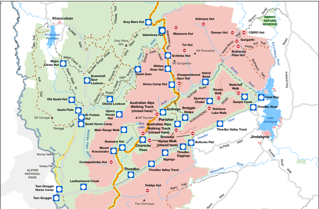
If you’re planning to walk the Snowies Alpine Walk in November 2026 or another of the other majory Snowy Mountains hikes, please be aware of scheduled closures in Kosciuszko National Park.
NSW National Parks and Wildlife Service (NPWS) will be conducting aerial pest control operations from Monday 9 November to Friday 27 November 2026.
During this period, affected areas will be closed every weekday from 5:45am to 8:15pm. Closure notices will be placed at relevant access points, and visitors must not enter closed areas. Penalties apply for non-compliance.
What does this mean for the Snowies Alpine Walk?
The following three sections of the Snowies Alpine Walk will be closed during the scheduled operations:
- Guthega to Charlotte Pass
- Charlotte Pass to Perisher Valley
- Perisher Valley to Bullocks Flat
This means the full Snowies Alpine Walk cannot be completed during these weekday closures. They are open as usual on Saturdays and Sundays.
Some other popular walks will remain open, including the Kosciuszko Walk, Summit Walk, Main Range Walk, Mount Stilwell Walk, Pallaibo Walk and Dead Horse Gap Walk.
As closures and access conditions can change, we strongly recommend checking the NPWS Kosciuszko National Park alerts before your trip and again before heading out each day.
Which walks will be affected?
As of 1.10.26, the affected walks include:
The following facilities and areas within Kosciuszko National Park will be closed:
- Rennix walk
- Rainbow Lake walk
- Porcupine walk
- Waterfall walk
- Illawong walk
- Snowies Alpine Walk: Guthega to Charlotte Pass walk
- Snowies Alpine Walk: Charlotte Pass Village to Perisher Valley walk
- Snowies Alpine Walk: Perisher Valley to Bullocks Flat walk
- Hannels Spur track
- The Main Range – Dicky Cooper Bogong south along Rolling Grounds (down to ~1300m elevation to West, ~1600m elevation to N, E) to Wilkinson Valley
- Ramshead Range – Merritts Creek east to Sawpit Creek
- Part of Perisher Range including Mount Guthrie (Snowy River east to Mount Paralyser)
- The area east of Guthega Link Road, eastwards to Diggers Creek
- The area east of Whites River corridor and west of the Brassy Mountains, including Disappointment Spur Hut, Tin Hut and Mawsons Hut
- Snowy Plain area, including Gungarlin River campground, Daveys Hut, Kidmans Hut, CSIRO Hut and Botherum Plain Hut
- The area east from Diggers Creek (Guthega Road) and north of Kosciuszko Road towards Jindabyne Pumping Station
- The area west of Dead Horse Gap walk and Kosciuszko walk , including North, Central and South Ramshead
- Cootapatamba Hut
- Pilot Wilderness Area, including Teddys Hut and Tin Mines Trail
- Moonbah, Grosses Plain and Ingebyra areas
The following facilities and areas will remain open:
- Resort areas
- Public road corridors
- The Australian Alps Walking Track (Cowombat Flat to Whites River Hut – refer to map of closed areas for diversions)
- The Whites River corridor, including Horse Camp Hut, Whites River Hut, Schlinks Hut, Valentines hut and Grey Mare Hut
- Kosciuszko walk
- Summit walk
- Summit trail
- Main Range walk
- Mount Stilwell walk
- Pallaibo walk
- Dead Horse Gap walk
- Thredbo River walk
- Thredbo Valley track (walking and cycling)
- The Pilot Wilderness mountain bike ride (Alpine Way to Barry Way), including Cascade, Ingeegoodbee and Nine Mile Trails
Staying at Knockshannoch?
If you’re booked to stay with us during November, please get in touch if you’re unsure how the closures affect your plans. We’re happy to help you understand which walks are available and work through alternative options for your stay.
For the most up-to-date information, contact the local NPWS office at np***********************@*****************ov.au or call 1300 072 757.
Please notes, these closures are annual. If you’re planning a trip in November 2027, be aware this will occur again.
Please always follow signage and NPWS instructions while in the park.
Leave a Reply